
Iona Sinikivi
Notice 2026 Municipal Budget and Fees
The Township of Drummond/North Elmsley Council has scheduled a Special Meeting in the Council Chambers on October 30th, 2025 at 9:00 a.m. to consider the 2026 Operating and Capital Budget and any changes in fees.
A Public Meeting to hear comments and answer questions from the public will be held on Tuesday, December 2nd, 2025 at 3:00 p.m. The Township strongly encourages written comments to be submitted prior to the public meeting.
The Township of Drummond/North Elmsley Council intends to adopt the 2026 Budget at the Council meeting to be held on December 9th, 2025 at 3:00 p.m.
Your participation at these meetings is welcome and encouraged. Copies of the draft budget will be available on the Township website as of October 27th, 2025 or by contacting the Treasurer.
DATED at Township of Drummond/North Elmsley this 3rd day of October, 2025.
For Further Information contact:
Angela Millar, Treasurer
Township of Drummond/North Elmsley
310 Port Elmsley Road
Perth ON K7H 3C7
Email: This email address is being protected from spambots. You need JavaScript enabled to view it.
T: 613-267-6500 Ext. 215
www.dnetownship.ca
UPDATE: Level 3 Low Water Advisory for the Rideau Valley Watershed

OCTOBER 10, 2025 - Due to persistent rainfall deficits, diminished baseflows and above average temperatures, the Rideau Valley Water Response Team is maintaining a Level-3 Low Water Advisory for the Rideau Valley Watershed after officials met to discuss conditions.
Level 3 conditions are triggered when rainfall deficits fall below 40% of the long-term average and/or when streamflows decline to severe low-water thresholds (typically below the 10-year return period low flow).
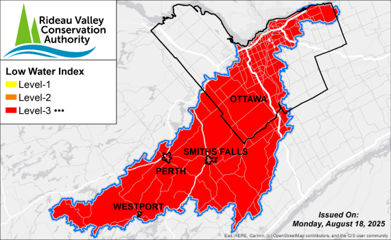
A Level 3 Low Water Advisory is not a declaration of an emergency, but an indicator of significant dry conditions and impacts observed across the Rideau Valley watershed.
The Rideau Valley Conservation Authority provides science-based advice and coordination during low water conditions but does not have the authority to enforce water use restrictions. Decisions related to restrictions or bylaws rest with individual municipalities and provincial agencies.
Historical Norms
The fall season is typically a crucial annual period where our surface water and groundwater systems are replenished. The cooler conditions, reduced plant-use of water, and consistent rainfall typically allow our soils and the underlying groundwater aquifers to be replenished. Under normal conditions, the region would receive between 80-100 mm of rain each month during the fall, contributing to gradual aquifer replenishment, which leads to subsequent baseflow* recovery.
*baseflow is the long-term sustained flow in a stream or river that comes from seepage out of our groundwater aquifers.
Current Conditions
Rainfall and streamflow conditions from July through to October have remained significantly below normal, with strong persistent deficits noted across the region. In addition, no clear signs of typical groundwater aquifer replenishment have been observed at select wells in the local groundwater monitoring network.
Rainfall
- Looking ahead, the 10-day Environment Canada forecast shows only limited precipitation, with total accumulations of 2–4 mm expected across the region. 90-day totals across the watershed are 40%–60% of the long-term average for this time of year
- 30-day totals are of particular concern, with most areas receiving less than 35% of normal rainfall.
Streamflows
- Streamflow and water levels have diminished significantly across all Rideau Valley subwatersheds
- Severely reduced to absent baseflows have resulted in prolonged critical low flow conditions in both Kemptville Creek and the Jock River, with several reaches now highly fragmented or disconnected.
- Kemptville Creek has experienced persistent periods of near-zero flow, with only brief fluctuations in response to minor rainfall events. Current conditions represent the lowest sustained flows on record (1969–present).
Groundwater
- Data from the Provincial Groundwater Monitoring Network indicate sustained and continuous declines in groundwater levels across the region, with select wells reaching new record lows within their 20- to 25-year period of record.
Navigation & Reservoir Levels
Parks Canada has advised that, due to ongoing dry conditions and limited rainfall, water levels along the Rideau Canal are expected to drop below navigation draft requirements shortly after the close of the 2025 navigation season on October 14. Water levels may recede more quickly than usual in reaches between Long Island and Burritts Rapids, Clowes and Merrickville, Merrickville and Kilmarnock, and Kilmarnock and Edmonds. The Parks Canada’s water management team continues to monitor conditions closely and will adjust operations as needed.
For further information, please contact: This email address is being protected from spambots. You need JavaScript enabled to view it.
Water levels within the upper watershed lakes and reservoirs remain below the long-term average. Following the close of the navigation season, outflows will be gradually reduced to operational minimums to conserve upstream storage and mitigate further declines in lake and downstream river levels.
Recommended Actions
Limited rainfall and groundwater recharge have caused an unusual lowering of the groundwater table; and reduced the baseflow that normally sustains our streams and rivers through late summer, fall, and winter. Although these conditions are natural, rather than the result of excessive human use, responsible water use remains important for mitigating further stress on the systems.
By lessening water use, users help sustain existing aquifer volumes, reduce pressures on shallow private wells and on our lakes, wetlands, streams, and rivers, until typical conditions return.
Permit Holders:
Holders of Permits to Take Water from surface or groundwater sources are strongly encouraged to reduce use, wherever possible. During low flow conditions, large surface & groundwater takings can significantly impact local water availability.
Private Wells:
Residents that rely on groundwater wells are encouraged to use water efficiently to help protect the shared aquifer system. Areas that rely on the shallow groundwater system are particularly vulnerable and already experiencing significant shortages. However, water conservation measures is also important for residents using deeper aquifers, as these systems are often connected to the shallower systems and parts of our surface water systems.
In Ontario, private wells are managed by their owners with some regulatory support from the province. Those experiencing well performance or groundwater level issues can consider the following actions.
- seek advice from the Ontario “Wells Help Desk”
- seek assistance from a licensed well contractor, which includes many plumbers based in rural areas
- consult with your municipality about possible bulk water supply services
- consult the provincial reference: Managing Your Water Well In Times Of Water Shortage
Municipal Surface and Groundwater Systems:
Residents connected to municipal water supplies should monitor their municipality’s official channels for updates on water use restrictions.
- Urban Ottawa:
Residents served by the City of Ottawa’s central drinking water system are not subject to the same water supply pressures, as this system draws from the Ottawa River.
- General Advisories:
All residents are encouraged to follow municipal updates for guidance on water conservation, water source conditions, and information on fire bans.
Conservation Authority staff continue to monitor conditions and communicate with water managers throughout the watershed. Updates to this message will be issued as conditions warrant.
More resources:
Ministry of Environment, Conservation and Parks - Wells Help Desk: https://www.ontario.ca/page/wells-your-property#section-4
Ministry of Environment, Conservation and Parks – Find a Licensed Well Contractor: https://www.ontario.ca/page/find-licenced-well-contractors
Ministry of Environment, Conservation and Parks – Managing Your Water Well In Times Of Water Shortage: https://www.ontario.ca/page/managing-your-water-well-times-water-shortage
Ontario’s Low Water Response program:
www.ontario.ca/page/low-water-response-program
City of Ottawa Dry Conditions Webpage: https://www.ottawa.ca/en/health-and-public-safety/emergency-preparedness/current-and-ongoing-emergencies/dry-conditions
RVCA website: www.rvca.ca
Hourly and daily streamflows and water levels:
https://www.rvca.ca/watershed-management/streamflow-and-water-levels
Commemorative calendar puts Rideau Valley’s natural beauty on display
RIDEAU VALLEY, October 8, 2025 – Bring the beauty of the Rideau Valley home in 2026! In honour of the RVCA’s upcoming 60th anniversary, we’ve created a high-quality 12-month wall calendar celebrating the watershed’s natural beauty.
Each month, rich landscape and wildlife photos will transport you to our watershed’s most breathtaking views, celebrate our biodiversity and honour the natural resources that protect and uplift us every day.
Presales are open for the 12x18 wall calendar, which was designed and printed locally with FSC-certified Canadian paper. At only $20 each or 3 for $50, the calendars make great gifts for anyone who loves to work, play or live in the Rideau Valley – or any nature lover on your holiday shopping list!
Calendars ordered by December 8 should arrive before Christmas. All prices include taxes and shipping.
Proceeds will support our charitable partner, the Rideau Valley Conservation Foundation. This local environmental charity supports the RVCA’s stewardship and water quality programs, provides outdoor education subsidies for low-income schools and families, and operates an established land trust protecting more than 8,850 acres of natural local lands.
Congratulations to the winning photographers featured in the calendar, to be announced in the coming weeks! And thank you to the hundreds of watershed residents and visitors who submitted their inspiring shots to our photo contest throughout 2025.
Visit www.rvca.ca/calendar to order your calendar today. For more information or help ordering online, contact This email address is being protected from spambots. You need JavaScript enabled to view it..

French eBooks and eAudiobooks now available at the Perth & District Library
French eBooks and eAudiobooks now available at the Perth & District Library
The Perth & District Union Public Library now provides access to Cantook, a digital collection of French eBooks and eAudiobooks. The platform hosts 11,000+ ebooks and 1,300+ audio titles from Franco-Ontarian, Québécois and international publishers, and for adults, teens and children. It also hosts a wide selection of current and popular translations, by authors such as Louise Penny, Kristin Hannah, Sarah J. Maas, and Michael Connelly.
“We're delighted to have access to this resource via the Ontario Library Service consortium, which will allow us to support our French readers with many more and regularly updated titles than we could on our own”, said Emily Fournier, Library Specialist - Adult & Senior Services.
The new French eBook and eAudiobook collection can be accessed with a Perth & District library card and at the following url: https://perthunionpubliclibrary.cantookstation.com/.
Possible Algal Bloom on Mississippi Lake
The Ottawa District Office of the Ministry of the Environment, Conservation and Parks (MECP) received a report regarding a possible harmful algal bloom.
That possible HAB was observed at 11:34 AM on Friday, October 3, 2025, at 155 McCreary’s Beach Road, (McCreary’s Beach Resort), Drummond-North Elmsley Township, at a pond, adjacent to Mississippi Lake.
Based on conversations with the Leeds/Lanark/Grenville Health Unit, a site visit will not be conducted. There are no public beaches, recreational camps, or small drinking water systems that draw drinking water from the lake.
Another possible HAB was observed at 3:25 PM on Saturday, October 4, 2025, on Charlie Drive in Drummond-North Elmsley Township, at Ebbs Bay, Mississippi Lake.
Based on conversations with the Southeast Health Unit, a site visit will not be conducted.
For general information on blue-green algae, please refer to the MECP’s website at Blue-green algae | ontario.ca.
Lanark County Internet Service Options
Lanark County Internet Service Options
Lanark County, ON — September 19, 2025
Lanark County has been made aware that residents who currently receive internet services from Community Fibre Company (CFC) may have their service interrupted in the coming weeks.
To support those impacted, the County is providing a list of internet service providers (ISPs) and tools to help residents find new connectivity options.
How to Find a New Internet Provider
Residents are encouraged to use the following tools:
- National Broadband Internet Service Availability Map
Search by address to view available providers, service types, and coverage.
https://www.ic.gc.ca/eic/site/139.nsf/eng/home
- AHSIP Interactive Map
Part of Ontario’s Accelerated High Speed Internet Program. Residents must click on the coloured roadway lines to view service details.
www.ontario.ca/page/ontario-connects-making-high-speed-internet-accessible-every-community
(Note: This map shows fibre builds underway by Bell, Rogers, and Xplore, expected to complete by 2025, though timelines may shift.)
ISPs Offering Immediate Solutions
Rogers Communications Inc.
Wireless broadband available in Montague, Beckwith, Carleton Place, and Lanark Highlands.
Visit www.rogers.com or a physical location:
- Carleton Place (515 McNeely Ave Unit 1B)
- Smiths Falls (60 Lombard St Unit 4)
Residents can leave with equipment and set up service immediately.
Bell Canada Ltd.
Visit www.bell.ca or their physical location in Smiths Falls (123 Lombard St Unit #7)
Storm Internet
Coverage in Montague, Beckwith, Carleton Place, and Lanark Highlands.
Visit https://www.storm.ca or their Perth location:
2896 Rideau Ferry Road, Unit 106, Perth
Phone: 613-267-3801
Technician visit required for signal check and installation.
Xplore
Offers 5G Ultra in many Ontario locations.
Visit https://www.xplore.ca or contact local distributor:
DKS Xplore, 27 Kearnsley Way, Stittsville
Phone: 613-218-8671
Technician visit required for setup.
Starlink
Satellite-based service available across Lanark County.
Visit https://www.starlink.com
Equipment shipped directly to residents; self-installation required.
Further resources will be added here as they become available.
Please note that, while Lanark County is committed to assisting residents affected by the outage by providing available information, we are not involved in any decision related to the service outage. If you are an effected customer, we encourage you to reach out directly to your provider for further information.
Lanark County 2025 Construction Update
For immediate release
September 15th, 2025
Lanark County 2025 Construction Update
Lanark County Public Works is pleased to provide this update on construction projects taking place in 2025. In total, 24.8 kilometers of roadway have been upgraded with paved shoulders, and 16.2 kilometers have had micro-surfacing completed. These upgrades represent a significant investment in infrastructure, safety, and accessibility for all road users.
Highway 43 (CR43)
From Station Road to Mazie Street, this section now features paved shoulders, completing a continuous stretch from Perth to Smiths Falls. This enhancement greatly improves cyclist and pedestrian safety.
Scotch Line Road (CR10)
From Glen Tay Road to Otty Lake Side Road, upgrades include paved shoulders and drainage improvements. A left-turn slip lane at Glen Tay Road has been added to improve traffic flow and safety.
Roadways upgraded with paved shoulders and improved drainage:
- Waba Road (CR20) -From Shaw Road southerly for 4.6 km
- Ferguson Falls Road (CR15) - From Pine Grove Road to Highway 7
- Highway 511 (CR511) From 3 km north of Tatlock Road northerly for 3.4 km
- Derry Side Road (CR17) From Beckwith 9th Line southerly for 1.9 km
Innovative Construction Practices
This season saw the successful trial of night paving on Highway 511, Ferguson Falls Road, Waba Road, and Derry Side Road. Based on its effectiveness, the County will permit night paving as an option for future projects.
Micro-Surfacing Pavement Preservation
- Maberly-Elphin Road (CR36): Robertsville Road to Elphin
- McDonalds Corners Road (CR12): Mill Avenue to Elphin
- Townline Road (CR7B): Joseph Street to McNeely Avenue
Blakeney Bridge Replacement
Construction on the Blakeney Bridge has been completed. The single-lane bridge has now been replaced with a modern two-lane modular structure featuring a widened shoulder and a dedicated pedestrian walkway.
5-Arches Bridge
Work on the bridge began in mid-August and is focused on replacing the concrete jackets surrounding the original stone footings in the Mississippi River. This phase is scheduled to continue through October of 2025, with temporary closures to facilitate dewatering access. In 2026, additional restoration will include the replacement of the parapet stones and the asphalt deck, requiring the closure of the bridge during the work.
OVRT (Ottawa Valley Recreational Trail)
Sections of the OVRT north of Almonte were resurfaced with new stone dust, improving trail conditions and user experience for cyclists, walkers, and other recreational users. Wayfinding signage is scheduled to be installed this fall.
Tay-Havelock Trail
More than 12 kilometers of the Tay-Havelock Trail have been resurfaced with new gravel and stone dust, extending from the trailhead westward. The work includes brushing and tree removal, drainage enhancements, granular base installation, and stone dust surfacing, with wayfinding signage also planned.
The County extends its sincere thanks to all residents and visitors for their patience and cooperation throughout this important construction season. These improvements will serve our communities for years to come.
Sean Derouin, Lanark County’s Public Works Director, celebrated these achievements, “This year’s road and bridge improvements reflect our commitment to building safer, more accessible infrastructure for everyone in Lanark County. We’re grateful for the public’s patience and support throughout the construction season.”
Traffic By-Law Changes Approved: Lanark County Council
For immediate release
September 11th, 2025
Traffic By-Law Changes Approved: Lanark County Council has approved key amendments to its Consolidated Traffic By-Law, aimed at improving road safety and traffic management in several communities.
The updates include:
- Extension of the Community Safety Zone (CSZ) on CR#23 Rosedale Road South to include the newly opened 22-acre Montague Park property, increasing protection for pedestrians near Montague Public School.
- Speed zone adjustments on CR#12 McDonalds Corners Road in Elphin, extending the 60 km/h zone by 90 meters eastward and installing radar speed signs to help reduce speeding into the residential area.
- Realignment of speed zones on CR#10 North Street, shifting the 50 km/h and 60 km/h zones westward to eliminate a long stretch of 60 km/h through undevelopable land.
“These changes reflect our commitment to safer roads and responsive traffic management,” said Sean Derouin, Director of Public Works. “They were developed through data analysis, community input, and collaboration with the Traffic Advisory Working Group and local municipalities.”
The Ontario Provincial Police (OPP) supported the inclusion of transitional speed zones, noting they enhance enforceability and reduce legal challenges. The cost of signage and implementation will be covered within the existing Public Works budget.
Implementation will follow the County’s Speed Management Policy, with post-installation monitoring to assess effectiveness. For more information contact: Sean Derouin, Public Works Manager, 1-888-9-LANARK, ext. 3194
Drummond-North Elmsley Official Plan Amendment Approved: Lanark County Council has approved Drummond-North Elmsley’s Official Plan Amendment No. 9 (OPA 9), following a comprehensive review to align with provincial planning policies.
OPA 9 introduces 109 updates to the municipality’s Official Plan, including revised schedules and a new Schedule C map. The changes enhance policy clarity, support implementation, and reflect public input gathered through extensive consultation. Lanark County is the Approval Authority for amendments to local municipal Official Plans.
“Drummond North Elmsley OPA 9 represents good land use planning, is consistent with matters of provincial interest and the County Plan and balances public interests,” said Mike Dwyer, Planning Manager for Lanark County.
Modifications to OPA 9 were implemented in granting the approval. These modifications were developed in consultation with Drummond North Elmsley and severe to ensure provincial interest conformity and ease of policy interpretation and application. For more information contact: Mike Dwyer, Planning Manager, 1-888-9-LANARK, ext. 1520
Addition to Carleton Junction Lease: Lanark County Council has approved an amendment to the lease agreement for Carleton Junction with the Town of Carleton Place. The amendment includes the addition of new parcels of land adjacent to the Ottawa Valley Recreational Trail (OVRT), which will be managed by the Town and developed for all-terrain vehicle (ATV) parking.
The OVRT corridor, owned by Lanark County, has long served as a vital recreational and economic asset for the region. Under the lease agreement, the Town of Carleton Place oversees the management of the property to ensure that all development aligns with its community goals and enhances public access and use.
“This amendment is a testament to the strong and successful partnership between Lanark County and the Town of Carleton Place,” said Kurt Greaves, Chief Administrative Officer of Lanark County. “By working together, we continue to support recreational development that benefits residents and visitors alike, while promoting economic vitality along the OVRT corridor.”
The newly added property will be used to create designated ATV parking areas, improving access and usability for trail users and supporting the Town’s broader vision for Carleton Junction as a hub for outdoor activity and tourism. For more information contact: Kurt Greaves, CAO, 1-888-9-LANARK, ext. 1101
1000 Books Before Kindergarten Launches at Perth & District Library
Press Release
FOR IMMEDIATE RELEASE
1000 Books Before Kindergarten Launches at Perth & District Library
A new self-directed program, 1000 books before Kindergarten, has launched at the Perth & District Union Public Library. Designed to encourage a love of reading, the 1000 Books Before Kindergarten program is just that - a parent reading books with their child every day.
“Reading and sharing a book with your child from the moment they are born helps them to develop pre-reader skills for kindergarten, such as understanding letter sounds and building a larger vocabulary”, said Heidi Taber, Children’s Librarian. “Reading a thousand books might sound daunting, but it’s very do-able. If you read one book a night with your child, you can complete the challenge in less than three years. If you read three books a night, you can read 1000 books in one year!”
Any child from birth to five years of age can participate. Families participating in this program receive a log sheet, stickers every 100 books read, and a free book when they reach 1000 books. Families can pick up tracking sheets from the Perth & District Union Public Library or download them from their website at www.perthunionlibrary.ca/1000books.
Please visit www.perthunionlibrary.ca/1000books or call the library 613-267-1224 for more information.
Carleton Place Curling Club Presents: Beyond Curling Social Scene
A Free program for seniors ( 55+) residing in Carleton Place and the surrounding Townships
No Curling Club membership needed.
Come join us for a light lunch and social time. Followed by a variety of card and board games.
Mondays at 11:30 for lunch, followed by 1 pm - 3:30 pm for games
Starting September 15th, 2025,
Location:
Carleton Place Curling Club
120 Patterson Crescent, Carleton Place
It’s a perfect time to learn a new game or play an old favourite!
To sign up, call or email Laura Garrett - 705-653-6747 This email address is being protected from spambots. You need JavaScript enabled to view it.
If transportation is needed, Laura can help!