
DNE (664)
Radon Testing Information Session
Tennyson Road - Temporary Closure
Cannabis Production Zoning Public Meeting
Watersheds Canada Shoreline Re-Naturalization and Bats
WANTED: Advisory Committee Members

Township of Drummond/North Elmsley, Tay Valley Township, and the Town of Perth - Joint Recreation Master Plan
The Township of Drummond/North Elmsley, Tay Valley Township, and the Town of Perth are embarking on the preparation of a joint Recreation Master Plan to guide the municipalities’ direction in planning recreational facilities and services. Sierra Planning and Management has been commissioned to develop the Master Plan. The principal objectives of the project are to determine community priorities and develop a series of recommendations and action steps to accommodate the current and future recreational needs of the three municipalities. The Plan will guide future investment in facilities, programs, services and partnerships.
Get involved!
The Master Plan will be developed through a comprehensive consultation process, including public engagement sessions and public and user group online surveys. Keep checking this webpage to follow progress of the project and see how you can provide your input to the Master Plan.
Proposed project and community engagement timeline
- Public introductory meetings:
- Sat July 20th from 09:30 to 11:30 am at the Lanark County Council Chambers, 99 Christie Lake Road, Perth, ON K7H 3C6
- Tues July 23rd from 5:30 to 7:30 pm at the Lanark County Council Chambers, 99 Christie Lake Road, Perth, ON K7H 3C6
- Online public and user group survey: Commencing late July 2019
- Public Open House: Mid-October 2019
- Submission of the final Joint Recreation Master Plan: Early December 2019
Public Meeting - Road Closure and Conveyance of Unopened Road Allowance
Mississippi Lake Flooding Disaster Recovery Assistance Program Activated
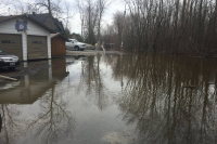
For more information on flooding please visit the health unit website or call the Health ACTION Line at 1-800-660-5853.
FLOODING REPORTS
Mississippi Valley Conservation Authority
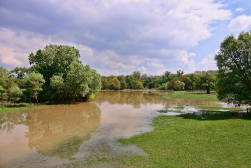
WATERSHED CONDITIONS STATEMENT
MISSISSIPPI RIVER WATERSHED - WATER SAFETY - May 5, 2026
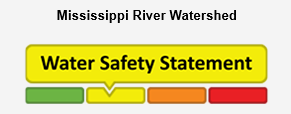
A Water Safety Statement is to provide notice of high flows, unsafe banks, melting ice or other factors that could be dangerous for recreational users such as anglers, canoeists, hikers, children, pets, etc. Flooding is not expected.
This Water Safety Statement is an update to the Flood Watch for the Mississippi River Watershed issued on April 28, 2026.
Weather Forecast: Seasonal temperatures are expected over the next two weeks, with daytime highs in the 10–15°C range. Light precipitation is forecast over the next seven days, with cumulative totals up to 30 mm. No significant weather systems are currently anticipated.
Watershed Conditions: Water levels and flows are gradually returning to seasonal norms. Some lakes remain in water safety conditions, and spring rainfall events may temporarily elevate additional lakes into similar conditions.
At this time, water levels and flows are not expected to increase significantly, and system operations are transitioning toward maintaining stable conditions for summer recreation and seasonal water use.
Risks: Rivers and streams may experience higher water levels, fast flowing water and slippery or unstable banks.
Actions: Residents are reminded to exercise extreme caution near all water bodies due to high flows and slippery conditions. Parents are encouraged to remind children about these dangers and provide appropriate supervision.
Residents in flood prone areas are advised to maintain close watch on water levels and flows and take the necessary precautions to protect their property by:
- Ensuring sump pumps are clear, in good working condition and have a backwater valve.
- Having a portable generator and backup pump available.
- Ensuring downspouts are clear and the outlet is at least 3 meters from any structure.
- Removing or securing items that might float away if flows increase.
- Keeping emergency phone numbers handy.
- Familiarizing yourself with your municipality’s emergency preparedness plan.
Duration: This message is in effect until May 12, 2026 at 5:00PM or until an update has been issued.
For More Information: Daily water levels and flows are available on the MVCA website at www.mvc.on.ca/water-levels. For more information, contact:
MVCA Water Management
613-253-0006 ext. 248
This email address is being protected from spambots. You need JavaScript enabled to view it.
NEWSROOMS PLEASE NOTE:
A Watershed Conditions Statement is NOT a flood warning. Its purpose is to raise public awareness about a change or potential change in watershed conditions.
See below for watershed conditions terminology:
Watershed Conditions Statement: General notice of weather conditions that could pose a risk to personal safety or which have the potential to lead to flooding. There are two variations of these:
- Water Safety Statement: High flows, unsafe banks, melting ice or other factors could be dangerous for recreational users such as anglers, canoeists, hikers, children, pets, etc. Flooding is not expected.
- Flood Outlook Statement: Early notice of the potential for flooding based on weather forecasts calling for heavy rain, snowmelt, high wind or other conditions that could lead to high runoff, cause ice jams, lakeshore flooding or erosion.
Flood Watch: Flooding is possible in specific watercourses or municipalities. Municipalities, emergency services and individual landowners in flood-prone areas should prepare.
Flood Warning: Flooding is imminent or already occurring in specific watercourses or municipalities. Municipalities and individuals should act to deal with flood conditions. This may include road closures and evacuations.
More...
Changes to the Municipal Conflict of Interest Act require municipalities to maintain a registry of all declarations made under this Act. The registry must include the original written declaration provided by the member of Council and must be available to the public.
A tabular version of the registry is available online, sorted by Member of Council name which provides the Member’s name, the date of the meeting where the declaration was made, where the declaration was made (Council or Committee name) and the nature of the declaration from the form submitted by the Member.
Declaration of Interest Registry
| Member of Council | Meeting Date | Meeting | Item | Nature of Declaration |
|---|---|---|---|---|
| Paul Kehoe | 10-Mar-26 | Council | 8.1 | Family owned property (spouse) |
| Paul Kehoe | 24-Feb-26 | CoW | 7.1 | Family owned property (spouse) |
| Paul Coutts | 26-Aug-25 | CoW | #10.1 | Personal matter involves a relative |
| Paul Coutts | 11-Feb-25 | CoW | #10 | Principal residence is in close proximity to proposed gun range |
| Paul Coutts | 12-Nov-24 | CoW | Closed Session 10.1 | Principal residence is in close proximity to proposed gun range |
| Paul Coutts | 14-Nov-23 | CoW | Closed Session 10.3 | Principal residence is in close proximity to proposed gun range |
| Paul Kehoe | 10-Oct-23 | CoW | Hazardous Building Materials Assessments Item 7.3 A | Employed by Pinchin until 2022 |
| Paul Coutts | 10-Oct-23 | CoW | Closed Session 10.1 | Principal residence is in close proximity to proposed gun range |
| John Matheson | 13-Jun-23 | Council | Zoning Amendment Item 8.1 | Applicant of Zoning Amendment is his nephew |
| Paul Coutts | 13-Jun-23 | CoW | Closed Session Item 10.1 | Principal residence is in close proximity to proposed gun range |
| John Matheson | 23-May-23 | CoW | Zoning Amendment Item 7.1A | Applicant of Zoning Amendment is his nephew |
| Paul Coutts | 09-May-23 | Council | CoW Report 7 Item A.1 & B.1 | Principal residence is in close proximity to proposed gun range |
| John Matheson | 11-Apr-23 | CoW | Zoning Amendment Item 5.2 & 7.1B | Applicant of Zoning Amendment is his nephew |
| Paul Kehoe | 24-Jan-23 | Council | Tractor Compensation Item 8.1 | Compensation for personal tractor use as donation for Drummond/North Elmsley Trail |
| Paul Kehoe | 13-Dec-22 | CoW | Tractor Compensation Item 10.3 | Compensation for personal tractor use as donation for Drummond/North Elmsley Trail |
| Paul Coutts | 13-Dec-22 | CoW | Communications List Item 6.1 | Principal residence is in close proximity to proposed gun range |
| Paul Coutts | 06-Dec-22 | CoW | Special Meeting | Principal residence is in close proximity to proposed gun range |
| Ray Scissons | 22-Nov-22 | Council | Road Closure Item 6.1 | Property is owned by his Spouse |
| Ray Scissons | 08-Nov-22 | CoW | Road Closure Item 7.3 -B | Property is owned by his Spouse |
| Paul Kehoe | 09-Aug-22 | CoW | Integrity Commissioner Report Item 10.2 | Code of Conduct Report concerning his actions |
| John Matheson | 12-Apr-22 | CoW | Snowmobile Trail Item 10.1 | Trail would run through his brother's property |
| John Matheson | 22-Mar-22 | CoW | Snowmobile Trail Item 9.1 | Trail would run through his brother's property |
| John Matheson | 8-Mar-22 | CoW | Snowmobile Trail Item 5.5 | Trail would run through his brother's property |
Always drain your pool properly, so as not to harm the environment!
The Swimming Pool By-law states, "No person shall construct or place a pool on his or her property without first obtaining a Pool Permit.
Changes to Building & Planning Fees effective March 1, 2019
John Matheson

John Matheson is a newly elected Deputy Reeve. John was born and raised on a family farm in Drummond Township.
John farmed in Drummond Centre were he proudly raised his 3 sons while working for 34 years at Brewers Retail, after retiring John and his wife Ewa moved to a new home on the Tennyson Road.
John was a director of the Cattlemans Association, president of the Perth Blue Wings Junior B team, a member and volunteer of the Perth Civitan, and volunteer for minor hockey and baseball.
I feel privileged to have been elected to serve the good people of DNE.
Additional Info
- Contact Name Deputy Reeve – Drummond Ward
- Phone 613-264-6129
- Email This email address is being protected from spambots. You need JavaScript enabled to view it.