
Super User
Water Levels To Remain High Across Rideau Valley
The Flood Warning and Flood Watch issued on April 6, 2023 remains in effect for the Rideau Valley watershed. Flood conditions are present in many low-lying areas adjacent to several rivers, lakes, creeks and ditches. Additional areas have the potential to flood next week, as the remaining snow within the City of Ottawa and the Tay River watershed is expected to finish melting due to multiple days with high temperatures in the double digits.
The short-term weather forecast indicates no precipitation for next few days. Staring on Monday April 10, 2023, temperatures will remain above zero all day with high temperatures in the double digits.
Based on the above, water levels and flows are generally expected to either remain elevated or increase in all waterways in the Rideau Valley Watershed throughout next week. Some specific areas of concern are highlighted below:
A FLOOD WARNING remains for the following areas:
- Properties around Bob’s Lake, Christie Lake and Tay River in the upper Rideau Valley Watershed. Parks Canada staff are closely monitoring the water levels in Bobs Lake and Christie Lake, and operations at the Bolingbroke Dam will take place as required, to balance the levels in Bobs Lake and Christie Lake.
- Flooding impacts are occurring and expected to continue in the following areas:
- Properties around the smaller creeks and streams in the lower Rideau Valley Watershed, including the low-lying roads and waterfront properties adjacent to Stevens Creek (near North Gower), and any connected creeks or ditches. Although water levels have receded, some risk of further increase exists with the remaining snowpack.
- The Rideau River between Becketts Landing and Manotick, including Kemptville Creek. The water levels throughout this reach are expected to remain high for at least the next week.
A FLOOD WATCH remains for the following areas:
- Properties around Big Rideau Lake, Upper Rideau Lake, and along the Rideau River from Smiths Falls through Burritts Rapids.
- Low-lying properties (close to Rideau River) on Rideau River Lane and the community of Rideau Gardens. Water levels in this area will remain elevated for at least the next week and may increase somewhat as the snowmelt continues upstream.
With the elevated conditions, potential exists for further impacts if significant additional rain were to occur before the water levels and flows begin to recede.
Due to the presence of ice cover on the lakes mentioned above and the anticipated water level increases, there is a concern for shoreline damage due to large pieces of ice becoming mobile.
With changing water levels expected over the coming days, ice cover on lakes, ditches, local streams and rivers will continue to be unstable. Extreme caution should be exercised when near local waterbodies. Parents should inform their children of the risks and provide appropriate supervision.
As temperatures continue to rise, the potential for ice jams remains high in some local streams and rivers, as flows could quickly increase before the ice can melt. Residents are advised to monitor their local river closely for signs of ice jams as spring progresses. RVCA staff will be monitoring conditions but we always welcome unique observations from watershed residents.
Flooding along roadways is also a concern due to current snow/ice buildup on roadside ditches.
Residents in flood-prone or low-lying areas that are historically susceptible to flooding should take the necessary precautions to protect their property, such as:
- Ensuring sump pump is clear, in good working condition and has a backwater valve
- Ensuring easy access to a portable backup generator and pump
- Ensuring downspouts are clear and the outlet is at least 3 metres from the dwelling
- Securing items that might float away as flows increase
- Removing valuable items from basements or lower floors that could be subject to flooding
- Keeping emergency phone numbers handy
- Familiarizing yourself with your municipality’s Emergency Preparedness Plan
This watershed conditions statement is in effect until Friday, April 14, 2023 and may be updated at that time unless the forecast or conditions change.
More Information:
Brian Stratton, RVCA Manager Engineering Services
Rideau Valley Conservation Authority
613-692-6804, 1-800-267-3504 ext. 1141
This email address is being protected from spambots. You need JavaScript enabled to view it.
www.rvca.ca/watershed-conditions
"Rideau Valley Conservation Authority is a partnership of municipalities within the Rideau Valley watershed created under the Conservation Authorities Act to deliver a range of programs in watershed management and natural resource conservation."
RVCA Watershed Conditions Statements:
Water Safety – High flows, unstable banks, melting ice or other factors that could be dangerous for recreational users such as anglers, canoeists, hikers, children, pets, etc. Flooding is not expected.
Flood Outlook – Early notice of the potential for flooding based on weather forecasts, calling for heavy rain, snow melt, high winds or other conditions that could lead to high runoff, cause ice jams and/or lakeshore flooding or erosion.
Flood Watch – Flooding is possible in specific watercourses or municipalities. Municipalities, emergency services and individuals in flood prone areas should prepare.
Flood Warning – Flooding is imminent or already occurring in specific watercourses or municipalities.
Flood Warning Statement FLOOD WARNING issued for Dalhousie Lake and Clyde River
MISSISSIPPI AND CARP RIVER WATERSHEDS— The Mississippi Valley Conservation Authority has upgraded its FLOOD WATCH to a FLOOD WARNING for Dalhousie Lake. Levels on the lake have continued to rise as the remainder of the snowmelt enters the watershed. With no rain in the forecast levels are expected to stabilized as soon as runoff rates subside over the next couple of days.
A FLOOD WARNING is in effect for the CLYDE RIVER. Flows on the Clyde and Fall rivers continue to rise at a steady rate and are expected to slow but continue to increase over the next two days.
Flows within the Indian and Carp Rivers appear to have peaked and are expected to continue to trend downward.
Smaller creeks, tributaries and ditches are flowing full over overtopped in numerous areas of the watershed. Parents are encouraged to remind their children about hypothermia and the dangers of playing on or near ice covered surfaces or fast flowing water in ditches and smaller creeks. Residents are strongly urged to stay off all ice covered waterways.
Residents in flood prone or low-lying areas historically susceptible to flooding should take the necessary precautions to protect their property, such as:
• Ensuring sump pump is clear, in good working condition and has a backwater valve on it
• Portable backup generator and pump
• Ensuring downspouts are clear and the outlet is at least 3 m from the dwelling
• Removing or securing items that might float away as flows increase
• Removing valuable items from basements or lower floors that could be subject to flooding
• Keep emergency phone numbers handy
• Familiarize yourself with your municipality’s emergency preparedness plan
This Watershed Conditions Statement is in effect until the end of the day on Monday, April 10, 2023 and will be updated at that time unless the forecasts change.
Please visit the MVCA’s website for more information on:
- Water levels and flow data: mvc.on.ca/water-levels
- Watershed Conditions Messages: mvc.on.ca/watershed-conditions-message.
Contact: Jennifer North
Water Resources Technologist
613-253-0006 ext. 243
This email address is being protected from spambots. You need JavaScript enabled to view it.
www.mvc.on.ca
See below for watershed conditions terminology:
Watershed Conditions Statement: general notice of weather conditions that could pose a risk to personal safety or which have the potential to lead to flooding. There are two variations of these:
- Water Safety Statement: High flows, unsafe banks, melting ice or other factors could be dangerous for recreational users such as anglers, canoeists, hikers, children, pets, etc. Flooding is not expected.
- Flood Outlook Statement: Early notice of the potential for flooding based on weather forecasts calling for heavy rain, snow melt, high wind or other conditions that could lead to high runoff, cause ice jams, lakeshore flooding or erosion.
Flood Watch: Flooding is possible in specific watercourses or municipalities. Municipalities, emergency services and individual landowners in flood-prone areas should prepare.
Flood Warning: Flooding is imminent or already occurring in specific watercourses or municipalities. Municipalities and individuals should act to deal with flood conditions. This may include road closures and evacuations.
Flood Watch Statement Rain and snow melt create potential for water levels to increase 10-20 cm on Dalhousie Lake
The Mississippi Valley Conservation Authority is issuing a FLOOD WATCH for Dalhousie Lake. With yesterday’s rainfall and the increased snow melt, levels on Dalhousie Lake could increase by 10-20 cm in the next few days. No significant flooding is expected in other areas of the watershed over the next three days.
The shoreline adjacent to lakes, rivers and creeks is very slippery and poses a serious hazard. Falling into open water could result in hypothermia or drowning. Ice conditions on lakes and rivers are deteriorating. Residents are strongly urged to stay off all ice-covered waterways.
The Mississippi Valley Conservation Authority (MVCA) reminds the public to exercise extreme caution around all water bodies:
- The public and pets should stay off all frozen water bodies.
- Parents are urged to remind children about the dangers of playing on or near ice covered surfaces and open water.
Residents in flood prone or low-lying areas historically susceptible to flooding should take the necessary precautions to protect their property, such as:
- Ensuring sump pump is clear, in good working condition and has a backwater valve on it
- Portable backup generator and pump
- Ensuring downspouts are clear and the outlet is at least 3 m from the dwelling
- Removing or securing items that might float away as flows increase
- Removing valuable items from basements or lower floors that could be subject to flooding
- Keep emergency phone numbers handy
- Familiarize yourself with your municipality’s emergency preparedness plan
This Watershed Conditions Statement is in effect until the end of the day on Monday, April 10, 2023 and will be updated at that time unless the forecasts change.
Please visit the MVCA’s website for more information on:
- Water levels and flow data: mvc.on.ca/water-levels
- Watershed Conditions Messages: mvc.on.ca/watershed-conditions-message.
Contact: Jennifer North
Water Resources Technologist
613-253-0006 ext. 243
This email address is being protected from spambots. You need JavaScript enabled to view it.
www.mvc.on.ca
See below for watershed conditions terminology:
Watershed Conditions Statement: general notice of weather conditions that could pose a risk to personal safety or which have the potential to lead to flooding. There are two variations of these:
- Water Safety Statement: High flows, unsafe banks, melting ice or other factors could be dangerous for recreational users such as anglers, canoeists, hikers, children, pets, etc. Flooding is not expected.
- Flood Outlook Statement: Early notice of the potential for flooding based on weather forecasts calling for heavy rain, snow melt, high wind or other conditions that could lead to high runoff, cause ice jams, lakeshore flooding or erosion.
Flood Watch: Flooding is possible in specific watercourses or municipalities. Municipalities, emergency services and individual landowners in flood-prone areas should prepare.
Flood Warning: Flooding is imminent or already occurring in specific watercourses or municipalities. Municipalities and individuals should act to deal with flood conditions. This may include road closures and evacuations.
FLOOD WARNING & FLOOD WATCH: Significant Rain Causes Water Levels To Rise Across Rideau Valley
A combined Flood Warning and Flood Watch is in effect for the Rideau Valley following a significant rain/freezing rain event on April 5, 2023. Flood conditions are present in many low-lying areas adjacent to several rivers, creeks and ditches. Additional areas have the potential to flood over the next few days, especially because of snow remaining within the City of Ottawa and the Tay River watershed.
The short-term weather forecast indicates no precipitation for next few days. Daytime temperatures will generally be above zero and night-time temperatures will be below zero for next few days. Temperatures are expected to stay above zero moving into next week.
Based on the above, water levels and flows are expected to increase or remain elevated in all waterways in the Rideau Valley Watershed throughout next week. Some specific areas of concern are highlighted below:
A FLOOD WARNING is being issued for the following areas:
- Properties around Bob’s Lake, Christie Lake and Tay River in the upper Rideau Valley Watershed. The water levels are expected to exceed full supply levels over the next 48 hours and may result in flooding for low-lying areas. Parks Canada staff are closely monitoring the water levels in Bobs Lake and Christie Lake, and operations at the Bolingbroke Dam will take place as required, to balance the levels in Bobs Lake and Christie Lake.
- Flooding impacts are occurring and expected to continue in the following areas:1. Properties around the smaller creeks and streams in the lower Rideau Valley Watershed, including the low-lying roads and waterfront properties adjacent to Stevens Creek (near North Gower), and any connected creeks or ditches.2. The Rideau River near Becketts Landing and Kemptville Creek, particularly the areas around Hilly Lane, Rideau Glen Lane, Golf Course Lane, Barts Lane and Cedar Beach Lane.3. The Rideau River near Kars, particularly the areas around Lorne Bridge Road and Rideau Street South.
A FLOOD WATCH is being issued for the following areas:
- Properties around Wolfe Lake and Big Rideau Lake
- Properties along the Rideau River from Smiths Falls through Burritts Rapids
- The Rideau River near Becketts Landing and Kemptville Creek, particularly the areas around Eligh Lane, Fennel Lane, Lannin Lane, Sheppard Lane, McGahey Lane, Sheilas Way and Harris Road
- Low-lying properties (close to Rideau River) on Rideau River Lane and the community of Rideau Gardens.
With the elevated conditions, potential exists for further impacts if significant additional rain or rapid snow melt were to occur before the water levels and flows begin to recede.
Due to the presence of ice cover on the lakes mentioned above and the anticipated water level increases, there is a concern for shoreline damage due to large pieces of ice becoming mobile.
With changing water levels expected over the coming days, ice cover on lakes, ditches, local streams and rivers will continue to be unstable. Extreme caution should be exercised when near local waterbodies. Parents should inform their children of the risks and provide appropriate supervision.
As temperatures continue to rise, the potential for ice jams remains high in some local streams and rivers, as flows could quickly increase before the ice can melt. Residents are advised to monitor their local river closely for signs of ice jams as spring progresses. RVCA staff will be monitoring conditions but we always welcome unique observations from watershed residents.
Flooding along roadways is also a concern due to current snow/ice buildup on roadside ditches.
Residents in flood prone or low-lying areas, historically susceptible to flooding, should take the necessary precautions to protect their property, such as:
- Ensuring sump pump is clear, in good working condition and has a backwater valve
- Ensuring easy access to a portable backup generator and pump
- Ensuring downspouts are clear and the outlet is at least 3 metres from the dwelling
- Securing items that might float away as flows increase
- Removing valuable items from basements or lower floors that could be subject to flooding
- Keeping emergency phone numbers handy
- Familiarizing yourself with your municipality’s Emergency Preparedness Plan
This watershed conditions statement is in effect until Friday, April 14, 2023 and may be updated at that time unless the forecast or conditions change.
More Information:
Brian Stratton, RVCA Manager Engineering Services
Rideau Valley Conservation Authority
613-692-6804, 1-800-267-3504 ext. 1141
This email address is being protected from spambots. You need JavaScript enabled to view it.
www.rvca.ca/watershed-conditions
"Rideau Valley Conservation Authority is a partnership of municipalities within the Rideau Valley watershed created under the Conservation Authorities Act to deliver a range of programs in watershed management and natural resource conservation."
RVCA Watershed Conditions Statements:
Water Safety – High flows, unstable banks, melting ice or other factors that could be dangerous for recreational users such as anglers, canoeists, hikers, children, pets, etc. Flooding is not expected.
Flood Outlook – Early notice of the potential for flooding based on weather forecasts, calling for heavy rain, snow melt, high winds or other conditions that could lead to high runoff, cause ice jams and/or lakeshore flooding or erosion.
Flood Watch – Flooding is possible in specific watercourses or municipalities. Municipalities, emergency services and individuals in flood prone areas should prepare.
Flood Warning – Flooding is imminent or already occurring in specific watercourses or municipalities.
COVID-19 Case Reported at COW Meeting
Please be advised that the Township was notified that a person attending the October 11, 2022 Committee of the Whole public meeting on the gun range rezoning proposal has since tested positive for Covid on October 13, 2022. The person reported that she had tested negative on both October 11th prior to coming to the meeting and October 12th. While attending the meeting, this person wore a mask and was sitting in the 2nd last row in Council Chambers.
For your safety and the safety of others, if you have any COVID-19 symptoms, please get tested.
Septic System Information
Sewage System Maintenance
How Can I Recognize If My Septic System is Having Problems?
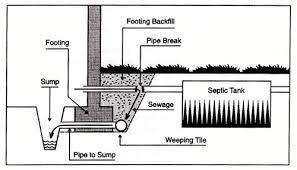 Diagram of Sanitary Sewage in Foundation
This diagram depicts sanitary sewage effluent that is being picked up in the perimeter weeping tile surrounding the house and is being drained into the internal sump pit in the building. This may indicate a break in the pipe between the building and the tank, which would cause the sanitary sewage to leak into the foundation backfill and into the weeping tile.
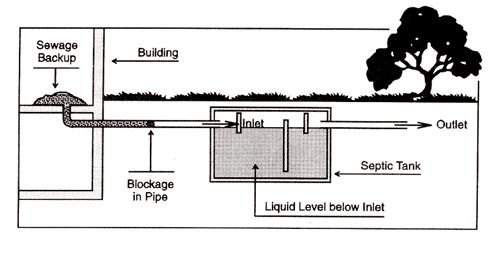 Diagram of Blockage in Inlet Pipe
A cause of sanitary sewage backup into a building is blockage of the pipes in the sanitary sewage system. If the sewage is backing up into the building the septic tank must be opened and examined. If the liquid level in the tank is below the level of the inlet pipe then there is a blockage between the building and the inlet of the tank. A plumbing contractor can remove this type of blockage using a plumbing snake.
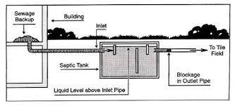 Diagram of Blockage in Outlet Pipe
If the level of sanitary sewage in the tank is above the inlet pipe, the blockage is on the outlet side of the tank and may be in the tile bed. A high level of sewage within the tank could also indicate that the entire leaching bed is saturated and that the ground can no longer absorb the liquid.
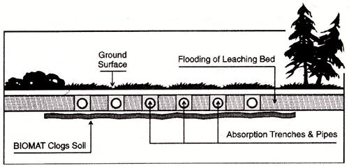 Diagram of Bio Mat
COVID-19 Impacts Perth Emergency Room Services
Smiths Falls, ON – In spite of our best efforts to preserve care in the Perth Emergency Department, COVID-19 has placed yet another burden on our fragile staffing situation. Today we learned of a COVID-19 outbreak impacting our Emergency Department Staff. This left the PSFDH team with no other option but to close the Perth Emergency Department effective Saturday, July 2 at 7 a.m. Available staff from the Perth Emergency Department will move to the Smiths Falls Site Emergency Department to support the anticipated increase in patients.
Residents in our catchment area can continue to access emergency care at the Smiths Falls Site located at 60 Cornelia Street West, Smiths Falls or the closest alternate emergency department.
At this time, this temporary emergency department closure will remain in effect until Thursday, July 7, 2022. As our staffing situation stabilizes, we will gradually reopen the Perth Emergency Department. Upon reopening, the Perth Emergency Department will open from 7 a.m. to 7 p.m.
We have informed our regional partners such as ambulance services, partner hospitals and public health regarding the upcoming closures.
The Smiths Falls Site Emergency Department continues to be open 24 hrs/day, seven (7) days per week as the reduction to Emergency Department hours impacts only the Perth Emergency Department.
PSFDH team continues to support our staff, and work with them, through this challenging time to ensure safe care for patients and to ensure safe and healthy working conditions for staff and physicians.
The PSFDH team appreciates your understanding and patience and as our staffing complement stabilizes, we will communicate any changes. Updates will be shared via our hospital Facebook page and through local media channels.
Anyone requiring immediate medical help should call 911 and paramedics will get you to the nearest emergency department for care.
Read the full media release from Perth and Smiths Falls District Hospital
Hockey Registration is Now Open!
Tay Valley Hockey
Registration forms are available at the Municipal Office and online at https://www.tayvalleytwp.ca/Hockey/
2022-2023 sessions will begin:
- October 2nd, 2022 for U8 (ages 6-7) and U11 (ages 8-10)
- October 6th, 2022 for U14 (ages 11-13), U16 (ages 14-15) and U18 (ages 16-17)
Early Bird Registration is only $200.00 per player!
($225.00 after September 9, 2022)
VOLUNTEERS NEEDED - contact 613-267-5353 ext. 110
New weather stations to improve forecasts, flood warnings across Rideau Valley
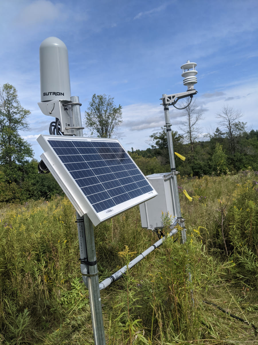 A new network of industrial weather stations will advance the Rideau Valley Conservation Authority’s capacity to track local weather, model future floods and track local climate change impacts into the future.
The RVCA has installed 11 new all-season weather stations across the watershed. These will fill gaps in the current data network, expand RVCA’s list of tracked weather parameters and provide real-time weather data online for use by residents, municipalities, farmers, researchers and even local forecasters.
“Our goal is to develop a watershed-wide model so we understand what’s happening in each part of the watershed,” said Brian Stratton, RVCA’s manager of engineering. “The new weather stations are a key piece in the development of a long-term model that can be used for hazard mapping, flood forecasting and tracking climate change trends.”
The industrial-strength stations – designed to withstand our coldest winters and hottest summers – will collect information on air temperature, dew point, relative humidity, air pressure, solar radiation, average wind speed and precipitation. The data is available through a new public portal on www.rvca.ca/weather-stations.
The addition of these stations will also improve Environment Canada’s ability to provide accurate weather forecasting for the region, as data from RVCA’s new stations will help corroborate what Environment Canada’s radar is predicting.
“It’s a nice relationship,” said RVCA’s hydrometric co-ordinator Justin Robert. “We’ve programmed these stations for our own purposes, but everyone in the watershed will benefit.”
Climate researchers will also rejoice – in 30 years, anyway.
“By recording the real time climate, it’s going to set us up for some extensive knowledge down the road,” Robert said. “These weather stations are going to give us this footprint of our weather into our future, and it will be invaluable information to really understand our watershed and what’s going on.”
To learn more about the RVCA's Flood Forecasting and Warning program, visit www.rvca.ca/watershed-conditions.
New weather stations are located in: Andrewsville, Bobs Lake, Frankville, Kars, Mansfield, Marlborough, Montague, Motts Mills, Rainbow Lake, Snowdons Corners and Westport. For more information contact This email address is being protected from spambots. You need JavaScript enabled to view it..