
Super User
Privacy Policy

Protecting the privacy and personal information of individuals is an important consideration in the way we structure our online and offline activities. When visiting our websites there is no requirement to identify yourself.
Every effort is made to ensure the information on the Township’s website is timely and accurate however, due to circumstances beyond our control, information and dates are subject to change without notice.
Wild Parsnip
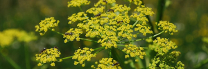
The Public Works Department will be documenting all Wild Parsnip on road allowances throughout the Township. The County of Lanark has further information on their website regarding noxious weeds.
For 2025, the Road Side Spray program will be spraying the locations listed in the following document.
2025 Spray Locations
Road Side spraying is expected to be completed between June 2 - July 4, 2025. It is weather dependent, and the Township will post a public notice prior to commencement.
If you do not want road side spraying adjacent to your property, please fill out a copy of the ‘No Spray Agreement’ and return to the Township office.
For further information please see Wild Parsnip- Best practices Ontario.
Building, Renovating, Demolition & Other Permits

Apply for a building or demolition permit using the online portal

Apply for a building or demolition permit using the PDF form

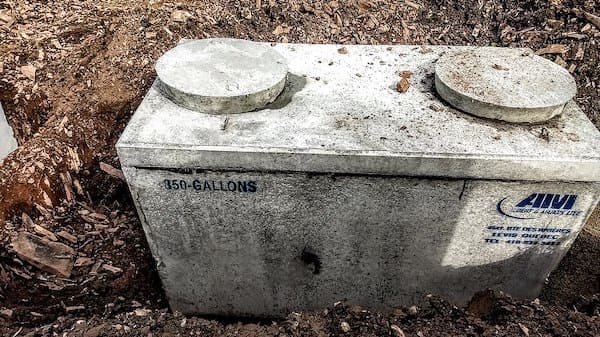
Septic Services
Other Permits & Forms
Frequently Asked Questions
Building Services Team
Peter Echlin
Chief Building Official
613-267-6500 ext. 240
This email address is being protected from spambots. You need JavaScript enabled to view it.
Rick Patterson
Building Inspector
613-267-6500 ext. 213
This email address is being protected from spambots. You need JavaScript enabled to view it.
Kyra Dobbie
Development Services Clerk
613-267-6500 ext. 232
This email address is being protected from spambots. You need JavaScript enabled to view it.
Permit Fees
| Building Permit Fee Schedule Excerpt From Tariff of Fees | |
|---|---|
| Residential Permits (Group C) | Permit Fee |
| New construction for residential and seasonal use. Includes plumbing, additions, renovations, accessory buildings and repair & replacement | $15.00 per $1000.00 for the first $100,000.00 and $7.50 per $1000.00 over $100,000.00 of Construction Value* Minimum permit fee is $150.00 |
| Assembly, Commercial, & Industrial (Group A,B,D,E,F) | Permit Fee |
| New construction, additions and renovations of Assembly, Commercial and Industrial buildings. Includes plumbing and accessory buildings | $15.00 per $1000.00 for the first $100,000.00 and $7.50 per $1000.00 over $100,000.00 of Construction Value Minimum permit fee $250.00 |
| Farm Structure ** | Permit Fee |
| Farm structure Up to 1500 sq. ft. Includes alteration or repair of existing | $8.00 per $1000.00 of Construction Value |
| Farm Structure 1501 to 6450 sq. ft. | $10.00 per $1000.00 for the first $100,000.00 and $5.00 per $1000.00 over $100,000.00 of Construction Value |
| Farm Structure Greater than 6450sq. ft. | $12.00 per $1000.00 for the first $100,000.00 and $5.00 per $1000.00 over $100,000.00 of Construction Value |
| Miscellaneous | Permit Fee |
| Solid Fuel Appliance (Wood stove, fireplace, outdoor boiler) | $150.00 |
| Swimming Pool | $150.00 |
| Demolition Permit | $150.00 |
| Plumbing Alteration | $150.00 |
| Hydronic Heating | $150.00 |
| Rooftop Solar Projects (Residential) | $15.00 per $1000.00 of Construction Value Minimum permit fee $150.00 |
| Transfer of Permit to New Owner | $100.00 |
| Conditional Permit | $150.00 and Signed Agreement |
| Re-activation of Permit | $150.00 + $100.00/Inspection |
| Change of Use | $15 per $1,000 for the first $100,000 and $7.50 per $1,000 over $100,000 of construction value Minimum permit fee is $150.00 |
| Investigations/Construct Without Permit or Authorization | Permit Fee |
| Discretionary surcharge for commencing construction without a permit or authorization | Additional 100% of Permit Fee |
*Construction value based upon current Construction Index of Eastern Ontario
**As defined in the Ontario Building Code
Download a copy of the Building Permit Fees
Septic Fees
| Sewage System Permit - For private sewage systems with flows up to 10,000 litres/day (See Note #1) | $850.00 |
|---|---|
| Tertiary Sewage System Permit Require Maintenance Agreement (for annual inspection) | $850.00 |
| Permit Renewal/Revision with no inspection | $65.00 |
| Permit Renewal/Revision with site inspection | $220.00 |
| Third Party Certificates | $65.00 |
| Site Inspections – including Septic Tank Replacement Only, Alterations, Class 2 & 3 Sewage Systems. | $385.00 |
| Maintenance Inspections Minor Variances/Zoning By-Laws/Building Renovations/Septic Re-inspections | $220.00 |
| Mandatory Septic Inspections | $0.00 |
| Severance Applications: | |
| First lot | $443.00 |
| Subsequent lots | $180.00 |
| Subdivision Plan Review | $215.00 per lot up to a max. fee of $5,000.00 + 13% HST |
| File Searches | $125.00 |
Note #1: The Ministry of the Environment will be responsible for sewage works where the design capacity is in excess of 10,000 litres/day under the Ontario Water Resources Act.
Other fees that may be applicable:
Township Development Charges:
| Residential | Green Energy | Non-Residential | ||||
|---|---|---|---|---|---|---|
| Single & Semi Detached Dwelling | Other Multiples | Apartments - 2 Bedrooms + | Apartments - Bachelor & 1 Bedroom | Special Care/Special Dwelling Units | (per 500kW generating Capacity) | (per sq.ft. of Gross Floor Area) |
| $6,135 | $4,621 | $3,499 | $2,507 | $2,364 | $4,436 | $2.40 |
Lanark County Development Charges : $1,036.00
Civic Address Sign : $120.00
Township Entrance Permit : $1,000 ($900 refundable deposit). For entrance onto a County road contact Lanark County at 613-267-4200
Electrical Permit see Electrical Safety Authority (1-877-372-7233)
Conservation Authority Permits
- Mississippi Valley Conservation Authority 613-253-0006 X 244
- Rideau Valley Conservation Authority 613-267-5353 X 131
Occupancy Groups
- Group A Occupancy – Assembly Occupancy
- Group B Occupancy – Care or Detention
- Group C Occupancy – Residential Occupancy
- Group D Occupancy – Business and Personal Service Occupancy Group E Occupancy – Mercantile Occupancy
- Group F Occupancy – Industrial Occupancy
Building, Planning & Septic Services


Building, Renovating & Demolition

Planning
Find your Zoning using the Interactive Map
Septic Services
Cemeteries

Here you will find an alphabetical list of cemeteries in the Township. For further information regarding inactive cemeteries please call the Township at 613-267-6500.
Additional Information
Legacy Farm Program

Drummond/North Elmsley is excited to re-launch its Legacy Farms Program as part of its 25th Anniversary celebrations. Farms in the Township that have been in the same family for 100, 150 or 200 years (as of the date of application) are eligible for legacy farm designation. Approved legacy farm owners will receive an official certificate recognizing the award at no charge. Applicants can also opt for a legacy farm sign at no cost.
Legacy Farm - Application Form is availabe and can be email to This email address is being protected from spambots. You need JavaScript enabled to view it. Hard copy forms are available at the Municipal Office.
During the 200th Anniversary of the Perth Military Settlement in 2016, over 35 farm properties in the Township were recognized. Drummond/North Elmsley Township partnered with Tay Valley Township on this project.
Water Levels To Remain High Across Rideau Valley

The Flood Warning and Flood Watch issued on April 6, 2023 remains in effect for the Rideau Valley watershed. Flood conditions are present in many low-lying areas adjacent to several rivers, lakes, creeks and ditches. Additional areas have the potential to flood next week, as the remaining snow within the City of Ottawa and the Tay River watershed is expected to finish melting due to multiple days with high temperatures in the double digits.
The short-term weather forecast indicates no precipitation for next few days. Staring on Monday April 10, 2023, temperatures will remain above zero all day with high temperatures in the double digits.
Based on the above, water levels and flows are generally expected to either remain elevated or increase in all waterways in the Rideau Valley Watershed throughout next week. Some specific areas of concern are highlighted below:
A FLOOD WARNING remains for the following areas:
- Properties around Bob’s Lake, Christie Lake and Tay River in the upper Rideau Valley Watershed. Parks Canada staff are closely monitoring the water levels in Bobs Lake and Christie Lake, and operations at the Bolingbroke Dam will take place as required, to balance the levels in Bobs Lake and Christie Lake.
- Flooding impacts are occurring and expected to continue in the following areas:
- Properties around the smaller creeks and streams in the lower Rideau Valley Watershed, including the low-lying roads and waterfront properties adjacent to Stevens Creek (near North Gower), and any connected creeks or ditches. Although water levels have receded, some risk of further increase exists with the remaining snowpack.
- The Rideau River between Becketts Landing and Manotick, including Kemptville Creek. The water levels throughout this reach are expected to remain high for at least the next week.
A FLOOD WATCH remains for the following areas:
- Properties around Big Rideau Lake, Upper Rideau Lake, and along the Rideau River from Smiths Falls through Burritts Rapids.
- Low-lying properties (close to Rideau River) on Rideau River Lane and the community of Rideau Gardens. Water levels in this area will remain elevated for at least the next week and may increase somewhat as the snowmelt continues upstream.
With the elevated conditions, potential exists for further impacts if significant additional rain were to occur before the water levels and flows begin to recede.
Due to the presence of ice cover on the lakes mentioned above and the anticipated water level increases, there is a concern for shoreline damage due to large pieces of ice becoming mobile.
With changing water levels expected over the coming days, ice cover on lakes, ditches, local streams and rivers will continue to be unstable. Extreme caution should be exercised when near local waterbodies. Parents should inform their children of the risks and provide appropriate supervision.
As temperatures continue to rise, the potential for ice jams remains high in some local streams and rivers, as flows could quickly increase before the ice can melt. Residents are advised to monitor their local river closely for signs of ice jams as spring progresses. RVCA staff will be monitoring conditions but we always welcome unique observations from watershed residents.
Flooding along roadways is also a concern due to current snow/ice buildup on roadside ditches.
Residents in flood-prone or low-lying areas that are historically susceptible to flooding should take the necessary precautions to protect their property, such as:
- Ensuring sump pump is clear, in good working condition and has a backwater valve
- Ensuring easy access to a portable backup generator and pump
- Ensuring downspouts are clear and the outlet is at least 3 metres from the dwelling
- Securing items that might float away as flows increase
- Removing valuable items from basements or lower floors that could be subject to flooding
- Keeping emergency phone numbers handy
- Familiarizing yourself with your municipality’s Emergency Preparedness Plan
This watershed conditions statement is in effect until Friday, April 14, 2023 and may be updated at that time unless the forecast or conditions change.
More Information:
Brian Stratton, RVCA Manager Engineering Services
Rideau Valley Conservation Authority
613-692-6804, 1-800-267-3504 ext. 1141
This email address is being protected from spambots. You need JavaScript enabled to view it.
www.rvca.ca/watershed-conditions
"Rideau Valley Conservation Authority is a partnership of municipalities within the Rideau Valley watershed created under the Conservation Authorities Act to deliver a range of programs in watershed management and natural resource conservation."
RVCA Watershed Conditions Statements:
Water Safety – High flows, unstable banks, melting ice or other factors that could be dangerous for recreational users such as anglers, canoeists, hikers, children, pets, etc. Flooding is not expected.
Flood Outlook – Early notice of the potential for flooding based on weather forecasts, calling for heavy rain, snow melt, high winds or other conditions that could lead to high runoff, cause ice jams and/or lakeshore flooding or erosion.
Flood Watch – Flooding is possible in specific watercourses or municipalities. Municipalities, emergency services and individuals in flood prone areas should prepare.
Flood Warning – Flooding is imminent or already occurring in specific watercourses or municipalities.
Flood Warning Statement FLOOD WARNING issued for Dalhousie Lake and Clyde River

MISSISSIPPI AND CARP RIVER WATERSHEDS— The Mississippi Valley Conservation Authority has upgraded its FLOOD WATCH to a FLOOD WARNING for Dalhousie Lake. Levels on the lake have continued to rise as the remainder of the snowmelt enters the watershed. With no rain in the forecast levels are expected to stabilized as soon as runoff rates subside over the next couple of days.
A FLOOD WARNING is in effect for the CLYDE RIVER. Flows on the Clyde and Fall rivers continue to rise at a steady rate and are expected to slow but continue to increase over the next two days.
Flows within the Indian and Carp Rivers appear to have peaked and are expected to continue to trend downward.
Smaller creeks, tributaries and ditches are flowing full over overtopped in numerous areas of the watershed. Parents are encouraged to remind their children about hypothermia and the dangers of playing on or near ice covered surfaces or fast flowing water in ditches and smaller creeks. Residents are strongly urged to stay off all ice covered waterways.
Residents in flood prone or low-lying areas historically susceptible to flooding should take the necessary precautions to protect their property, such as:
• Ensuring sump pump is clear, in good working condition and has a backwater valve on it
• Portable backup generator and pump
• Ensuring downspouts are clear and the outlet is at least 3 m from the dwelling
• Removing or securing items that might float away as flows increase
• Removing valuable items from basements or lower floors that could be subject to flooding
• Keep emergency phone numbers handy
• Familiarize yourself with your municipality’s emergency preparedness plan
This Watershed Conditions Statement is in effect until the end of the day on Monday, April 10, 2023 and will be updated at that time unless the forecasts change.
Please visit the MVCA’s website for more information on:
- Water levels and flow data: mvc.on.ca/water-levels
- Watershed Conditions Messages: mvc.on.ca/watershed-conditions-message.
Contact: Jennifer North
Water Resources Technologist
613-253-0006 ext. 243
This email address is being protected from spambots. You need JavaScript enabled to view it.
www.mvc.on.ca
See below for watershed conditions terminology:
Watershed Conditions Statement: general notice of weather conditions that could pose a risk to personal safety or which have the potential to lead to flooding. There are two variations of these:
- Water Safety Statement: High flows, unsafe banks, melting ice or other factors could be dangerous for recreational users such as anglers, canoeists, hikers, children, pets, etc. Flooding is not expected.
- Flood Outlook Statement: Early notice of the potential for flooding based on weather forecasts calling for heavy rain, snow melt, high wind or other conditions that could lead to high runoff, cause ice jams, lakeshore flooding or erosion.
Flood Watch: Flooding is possible in specific watercourses or municipalities. Municipalities, emergency services and individual landowners in flood-prone areas should prepare.
Flood Warning: Flooding is imminent or already occurring in specific watercourses or municipalities. Municipalities and individuals should act to deal with flood conditions. This may include road closures and evacuations.